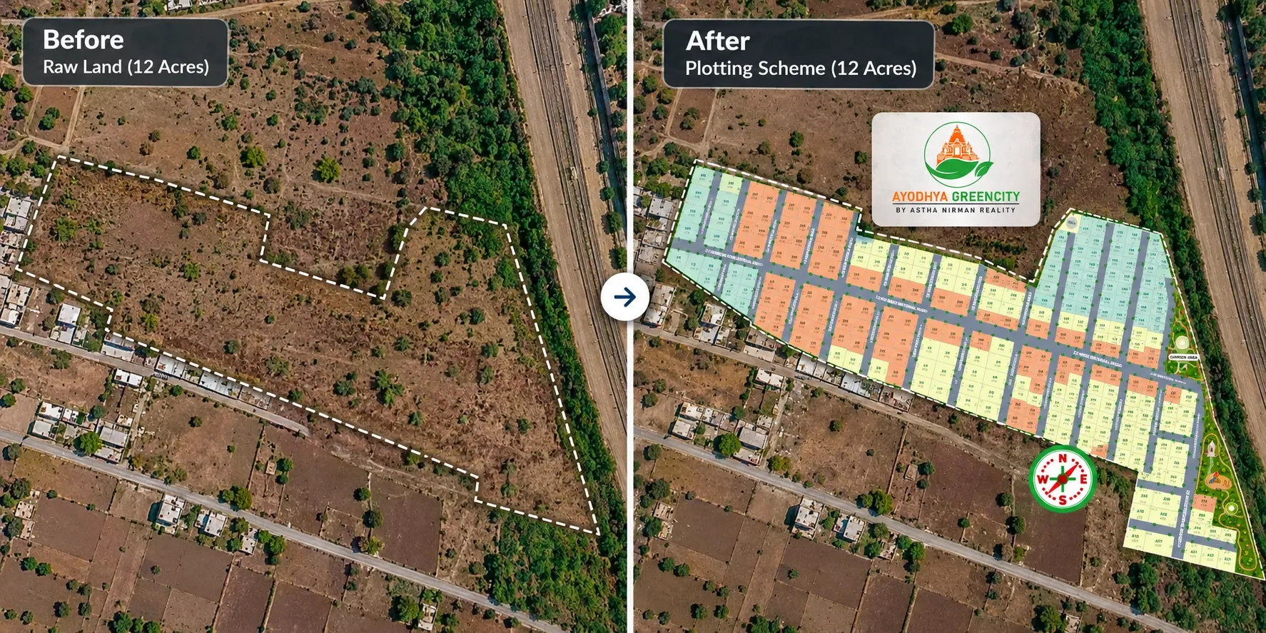
You have bought 12 acres on the edge of a growing town. Your architect is asking how many plots you want, what sizes, how wide the roads should be and where the garden goes. Every answer changes how much land you can sell and how fast it will sell.
Here is the short answer. A plotting scheme is the plan for dividing a piece of land into individual plots, along with the internal roads, open spaces, amenity areas and utilities that serve them. It decides how many plots you have, their sizes and their layout. Once approved by the local planning authority, it becomes the legal and commercial base of your plotted project.
This guide explains what a plotting scheme includes, how it gets approved in India, how it differs from a layout plan and a master plan, and the planning choices that affect sales later.
Key takeaways
A plotting scheme divides land into saleable plots plus the roads, open spaces and utilities they need.
Only part of your land becomes saleable plots. Roads, open space and amenity land take a large share, and local rules set minimums.
In India, a plotting scheme typically needs a clear title, land-use conversion, layout approval and, for most projects, RERA registration before you sell.
The plot mix and road pattern you choose shape your pricing, your sales speed and how easy the project is to explain to buyers.
An approved scheme is only the start. Buyers need to see and understand it, and your sales team needs to know which plots are still available.
Plotting scheme meaning
The term "plotting scheme" is used in two ways in India.
1. A developer's plotting scheme
This is a private project. A developer buys or develops land, plans it into plots, gets approvals and sells the plots to buyers. Most buyers will hear it called a plotted development, a plotting project or a layout. This guide focuses on this meaning.
2. A government or authority plot scheme
Development authorities and housing boards in many states also launch plot schemes. They develop land and offer plots to the public, often through an application and a draw. The planning logic is similar, but the selling process is set by the authority.
In both cases, the scheme answers the same questions: how many plots, of what size, served by which roads and supported by what common facilities.
What goes into a plotting scheme
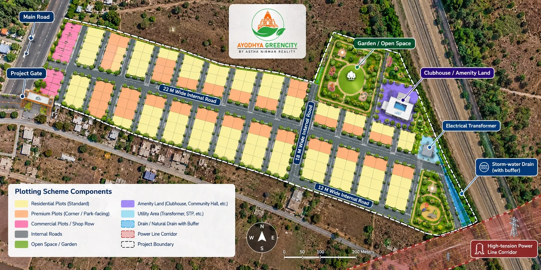
A plotting scheme is more than lines on paper. It is a set of decisions about how the land will be used. Most schemes include these parts.
Plots and plot mix
- Residential plots in one or more standard sizes
- Premium plots, such as corner, park-facing or main-road plots
- Villa plots, if you plan to offer built homes on some plots
- Commercial plots or a shop row, usually near the entrance
Internal roads
- A main spine road from the gate
- Secondary roads serving rows of plots
- Road widths that meet local rules, which often depend on road length and the number of plots served
Open space
- Gardens, parks and play areas
- Local rules usually require a minimum share of the land as open space
Amenity land
- Space for a clubhouse, community hall, temple or other shared facility
- Some authorities also require land to be reserved for public use
Utilities
- Water supply, sump or overhead tank
- Storm-water drains and sewerage, sometimes with a sewage treatment plant
- Electrical layout, transformer sites and street lighting
Constraints you plan around
- Natural drains, high-tension power lines and their corridors
- Road-widening lines and reserved land from the town's development plan
- Setbacks and boundary conditions
How much of your land becomes saleable plots?
This is the question every land developer asks first. The answer depends on your state's rules, the shape of your land and your road pattern.
Roads usually take the biggest share. Open space and amenity land come next, followed by utilities. In many plotted projects, saleable plot area ends up at roughly half to two-thirds of the total land. Check the exact minimums for open space, amenity land and road widths with your architect and the local authority, because they vary by state and by authority.
Two planning choices make the biggest difference:
- Road pattern. Long roads serving plots on only one side waste land. Roads with plots on both sides use it better.
- Land shape. Irregular boundaries create leftover corners that become odd-shaped plots or extra open space.
How a plotting scheme gets approved in India
The exact process differs by state, but most plotting schemes follow these broad steps.
Step 1: Verify title and land records
Confirm ownership, survey numbers, past transactions and any disputes. Everything else depends on clean title.
Step 2: Check zoning and land use
Check the town's development plan or master plan to confirm the land's zone permits residential plotting. Note any proposed roads or reservations that cross your land.
Step 3: Convert land use, if needed
Agricultural land usually needs non-agricultural (NA) permission or land-use conversion before it can be developed into plots.
Step 4: Prepare and submit the layout
Your architect or planner prepares the plotting scheme as a layout plan that meets local rules on plot sizes, roads, open space and amenities. It is then submitted to the relevant planning authority.
Step 5: Approval with conditions
The authority may approve the layout with conditions. In some states, roads and open spaces in an approved layout are handed over to the local body.
Step 6: Register with RERA
Under RERA, plotted projects generally must be registered before they are advertised or sold, unless they fall under the small-project exemption. The approved layout is part of the registration.
Step 7: Carry out development works
Build roads, drains, water and power lines as approved. Many authorities link plot release or completion certificates to this work.
Once approved, changes to the layout usually need a fresh approval. That is why getting the plot mix right before you submit matters so much.
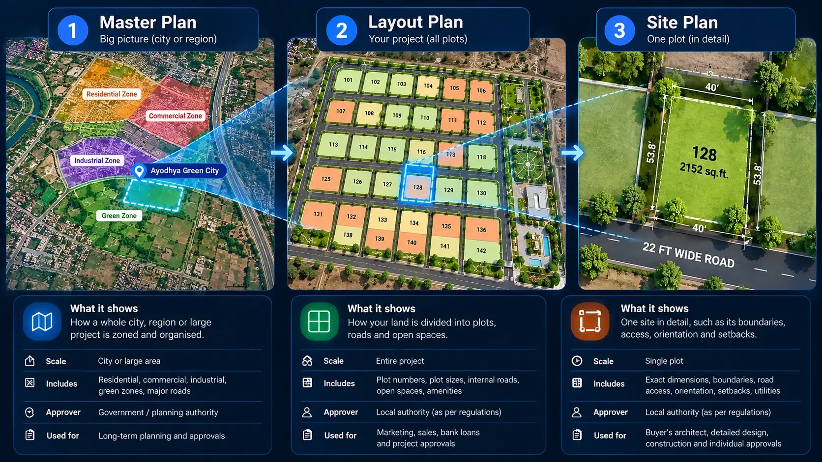
Plotting scheme vs layout plan vs master plan
These terms overlap, and people often use them interchangeably. Here is a simple way to tell them apart.
Plotting scheme
- What it is: the overall plan and idea for dividing the land into plots
- Who uses it: the developer, architect and sales team
- Focus: plot count, sizes, mix and commercial potential
Layout plan
- What it is: the technical drawing of the plotting scheme, with exact dimensions
- Who uses it: the approving authority, surveyors and buyers
- Focus: plot dimensions, road widths, open space and approval details
Master plan
- What it is: a bigger-picture plan, either for a whole city or for a large project with several phases
- Who uses it: planning authorities and large developers
- Focus: land use zones, major roads and how phases connect
For a deeper look at the drawings, read our guide on site plan vs master plan vs layout plan.
Example: planning a 12-acre plotting scheme near Ahmedabad
This is an illustrative scenario, not a client case study.
A developer has 12 acres, about 5,22,700 sq ft, on the outskirts of Ahmedabad. The land is close to a growing industrial belt, and the developer expects demand from salaried families and investors.
First draft
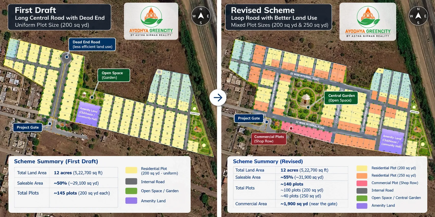
The architect's first draft uses a long central road with a dead end and plots of one size, 200 sq yd. After roads, open space, amenity land and utilities, the saleable area comes to about half the land.
What the developer changes
- Road pattern. The dead end becomes a loop, so most roads have plots on both sides. Saleable area rises to about 55% of the land, or roughly 31,900 sq yd.
- Plot mix. Instead of one size, the scheme now offers about 100 plots of 200 sq yd for first-time buyers and 40 plots of 250 sq yd for families who want more space.
- Premium plots. Plots facing the central garden and the corner plots on the main road are marked as premium.
- Commercial frontage. A row of commercial plots, about 1,900 sq yd in total, sits near the gate on the approach road.
The result
The scheme gives the sales team clear price bands and a story for each buyer type. It also gives buyers a reason to choose, rather than comparing about 145 identical plots.
Planning mistakes that slow down plot sales
Some plotting scheme decisions look fine on paper but cause trouble once sales begin.
- One plot size for everyone. It limits your buyer pool and leaves no room for price bands.
- Too many plots facing a drain, a transformer or the boundary wall. These become the last plots to sell.
- Premium plots without a reason. Calling a plot premium only works if the buyer can see why: a park, a wider road or a corner.
- Open space pushed to a corner. It meets the rule but adds little value. Central or well-placed open space lifts the plots around it.
- Confusing plot numbering. Gaps, repeats or numbers that jump across the layout make it hard for buyers and sales teams to find plots.
- No plan for phases. On larger land, releasing everything at once makes it harder to manage inventory and pricing.
Many of these issues show up later as sales problems. Our list of site plan presentation mistakes covers what happens when the plan reaches buyers.
From approved scheme to plot sales
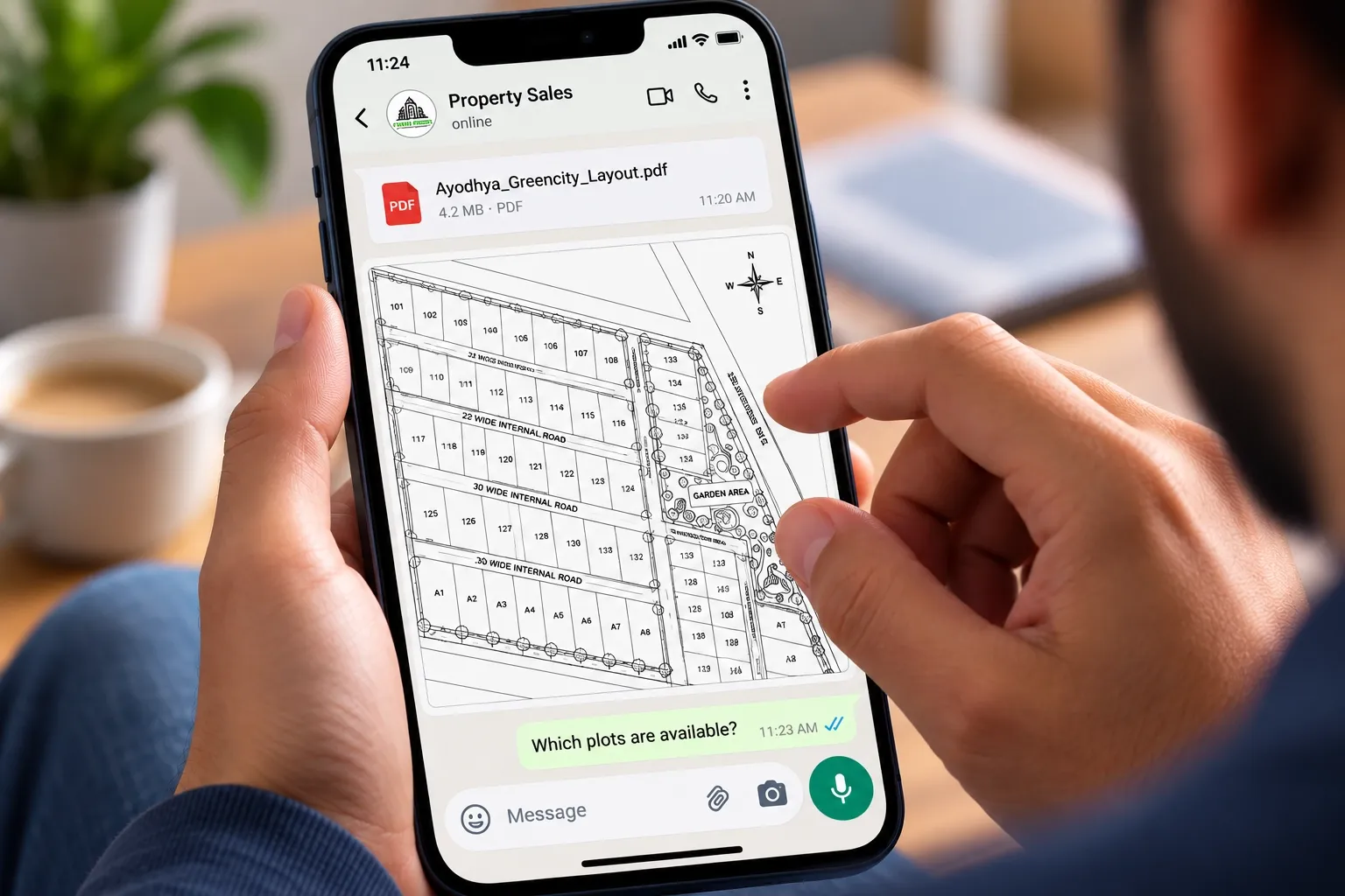
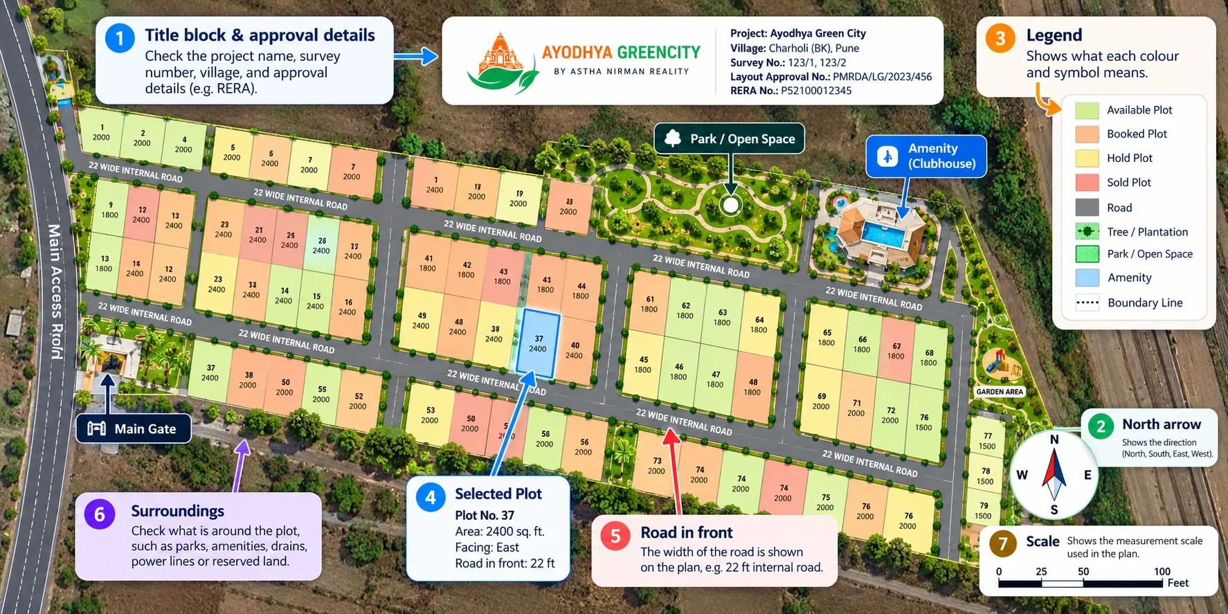
An approved plotting scheme is a technical document. Buyers rarely understand it on first look. They want to know where a plot is, what is next to it, which way it faces and whether it is still available. Our guide on how to read a site plan shows how much work that is for a buyer holding a PDF.
Your sales team faces the other side of this. As plots get booked, the PDF layout and the brochure fall out of date. The team relies on Excel sheets and phone calls to check availability, and the risk of double booking grows.
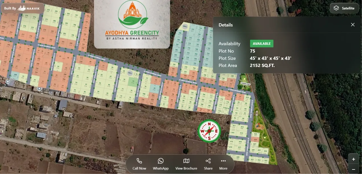
Plotter by Naavik.ai is plot management software that turns static layouts into interactive 3D site plans with real-time plot availability.
With Plotter, your approved plotting scheme becomes a 3D site plan placed over Google Maps or OpenStreetMap. As plotting scheme software for the sales stage, it lets buyers click any plot to see its number, size, facing and status: available, booked, hold or sold. Your team updates bookings in one place, and the built-in CRM captures every enquiry. Nearby landmarks and connectivity show buyers what surrounds the project, even before development work is complete. If you're launching before roads are built, our pre-launch plot marketing playbook explains how to use this early.
The result is fewer repeat explanations, fewer availability mix-ups and a scheme buyers can understand from their phone.